Process of carry of the weighed material in lake Issyk-Kul on space snapshots.
Mandychev Alexsandr Nikolaevich IVP&HP NAS KR
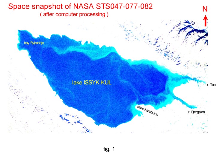
The analysis of process of carry of the weighed substance, basically clay and dust of fractions, superficial currents of lake a Issyk-Kul is executed on space snapshots NASA: 1) STS047-077-082 (September, 1992) (fig. 1), 2)STS091-715-005 (June, 1998), (http: // earth.jsc.nasa.gov/geon.html).
Most informative is the snapshot 1, executed in an autumn maximum of atmospheric precipitation and accordingly maximum superficial wash-out sedimentary of rocks of a land, is direct in lake and rivers running into lake. On this snapshot is well traced the structure of currents and intensity wash-out of the weighed material in various parts of lake. On a snapshot 2, executed in the summer period, the intensity of process wash-out of a sedimentary material is insignificant and is observed, basically, in east part of lake and is fragmentary on other water area. The character of a configuration of train transposition of a suspension in this period, in east part of lake, testifies to rather high speed regional cyclone of movement of lake waters. It confirms by, that the vectors of carry sedimentary of a material in a "shadow" zone, to the north of cape Karabulun have the same orientation, as vectors to the south of this cape. Pays on itself attention smaller speed of currents in the autumn period on a snapshot 1, that is visible on a configuration of train of carry of the weighed material not having precisely expressed vectors, similar observable on snapshot 2.
As a whole, the greatest interest is represented by features of trajectories of train of carry on a background already known regional of a cyclone direction of superficial currents of lake. In particular, on a snapshot 1 is fixed the fact of turbulent movement of flows of lake water, reflected in them festoon or sine wave trajectories. The source of the weighed material is well traced, just as its further moving and mixture. On a snapshot 1 it is possible to assert, that on the moment of shooting, the basic regional lake flow has not penetrated in Rybachinsky gulf and the weighed material was not transferred on its water area, that can testify to the rather detached hydrodynamical mode of a Rybachinsky gulf. Same it is possible to tell and about east part of lake, located to the east of a meridian, taking place on western extremity of cape Karabulun, where expand the "shadow" zone for regional cyclone of current and where is formed in during low speeds of current (autumn, winter), hydrodynamical mode is determined in the basic rivers, in particular, by rivers Tyup and Djergalan, average annual which drain - 33 ņ3/s, makes about 28 % of a drain of all rivers running into lake a Issyk-Kul. By the way, this fact in view of a configuration of lake is the essential precondition for formation of hydrodynamical potential, ensuring western direction of movement of lake water in lake along northern coast and promoting formation cyclone regional direction of currents. Indirectly it proves to be true by the maximal speeds of superficial lake currents
along northern coast of lake. On the basis of the considered snapshots it is possible to make a conclusion that the basic processes of carry of the weighed material and its maximal concentration gravitate to a coastal part of lake, the central part of lake is a little bit mentioned by these processes.
Thus, the analysis of the space snapshots, executed in the certain period of year, allows to reveal such features of processes of circulation of lake water both carry of the weighed and accordingly dissolved substance, which can not be established by other methods with enough high accuracy. It is obvious, that on the basis of the analysis of space snapshots for the various periods of time it is possible to construct objective model of circulation and carry, which is taking into account probability character of these processes in local scale on a background of regional determined process. It as allows more precisely to predict possible trajectories of carry of the weighed and dissolved substance in lake waters and sites of accumulation of polluting substances in lake.
In the methodical plan for realization the exact model of carry of the weighed substance by superficial lake currents suffices it is necessary to use as a lot of space snapshots in most typical seasons and for the greatest possible period of time is possible.
The addition of the analysis of snapshots by field definitions of speeds of current, concentration of the weighed material including on depth, it measurement and mineral structure in lake water will allow to create quantitative model of carry and accumulation sedimentary of a material in lake.
The basic problem in the mentioned above aspect is the availability of space snapshots to the concrete users for the decision of a various spectrum of research and applied tasks.